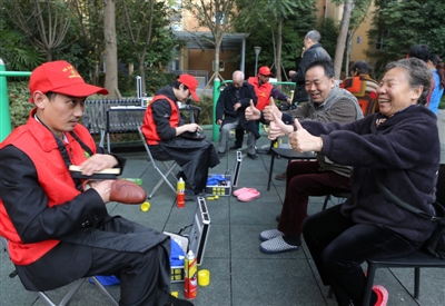
Residents of the community gave Dong Lianghong a thumbs up.
one person
I ate lunch at noon and started to play games. I didn’t go to sleep until 6 or 7 o’clock the next morning. After sleeping, I got up and continued to play. This kind of life lasted for 8 months, resulting in retinal detachment in both eyes. After three operations, I saved part of my vision and changed his life.
A team
I joined the volunteer service team and became a volunteer, hoping to bring my skills to those who need them more, and at the same time help those disabled people who are hiding in the dark corner like themselves, to bravely come out, integrate into society and face life optimistically.
Xiao Xiao, a 26-year-old boy from Chengdu, played games in front of the computer day and night for eight months, resulting in retinal detachment in both eyes, leaving only one eye with weak vision. Losing his light, he tried to commit suicide, but with the help of his family, friends and society, he walked out of the darkness. He not only became a blind masseur by himself, but also joined a special volunteer team to help others give back to society.
On the morning of November 14th, in dressing the, Xiao Xiao and the volunteer team came to Chengdu Wanjiafudi Community with a toolbox, providing services such as haircut, massage and shoeshine for the elderly and needy people here. What moved the residents at the scene was that these volunteers were all disabled, some of them were deaf and some were physically disabled. They were the service team for the disabled in Qingyang District of Chengdu and the first volunteer service team for the disabled in Sichuan Province.
"Self-improvement, self-confidence and gratitude are our slogans and the original intention of building a team." Zeng Guanghui, captain of the service team for the disabled in Qingyang District, Chengdu, said.
free service
Massage haircut shine shoes
Disabled volunteers come to serve the elderly and the weak in the community.
On November 14th, after several days of cold weather, the long-lost sunshine came out, making the earth warm. In Wanjiafudi Community, a group of volunteers wearing red vests and red caps are busy, having haircuts, massages and shining shoes, providing convenient services for the elderly and the weak here. The scene is very warm.
However, half an hour ago, when the volunteers first arrived, everyone just stopped to watch, and few residents received services. "They are all disabled people and people in need. How dare we ordinary people accept their free services?" Residents of the community said. It turned out that the volunteers who entered the community service this time were different from the past. They came from the disabled people’s service team in Qingyang District, Chengdu. The team members were all disabled, some were deaf and dumb, and some were physically disabled. Behind the volunteers, there is a poster with the words "self-improvement, self-confidence and gratitude" very eye-catching.
"Disabled people need self-improvement and self-confidence, and we should understand and respect them." Mr. Chen, the citizen, accepted the shoeshine service before he first came to the shoeshine booth. In Uncle Chen’s view, it is a good thing for disabled volunteers to provide services, which can prove their self-reliance and self-confidence. Everyone should understand and respect them. If they do well, they should be praised. Even if they are not good, they should be encouraged to improve their self-reliance.
When everyone learned the original intention of the volunteers, they enjoyed the free service of the volunteers and gave them a thumbs-up and praise.
"Teacher, my back has been hurting for two weeks. Please give me a massage." He Zihua, a 75-year-old man, accidentally bumped into his waist at home two weeks ago, put on a plaster, and still felt dull pain. When she saw Xiao Xiao, who provided massage service, she went forward for consultation. "You may have a bad breath in your abdomen. Let me massage it for you." Xiao Xiao arranged for the old man to sit down, gently knead it with his fingers, and carefully asked about the symptoms. After analysis, the symptoms of the old man’s abdominal rib bifurcation were ruled out, which may be caused by impact. It is recommended that the old man go to the hospital for another examination. The reporter noticed that in the process of massage, Xiao Xiao also set up a dragon gate array with the old man, such as how old he was, how many people in his family, and what he liked to eat. The whole communication process was very pleasant, and the old man did not have a different vision because he was disabled. For the service of volunteers, the old man expressed great gratitude. "I am old, my legs have been in car accidents before, and it is inconvenient to move. Thank them for providing services and helping us elderly people."
exert oneself constantly
Not only can I earn money and live independently.
You can also help others in need.
"I want to prove myself, and I can do what normal people can do." Xiao Xiao, 26, is a member of the volunteer team. After graduating from college, he worked in sales, earning seven or eight thousand yuan a month, and likes to get together and play with friends as much as young people. Three years ago, he quit his good job at that time and returned home to find a job. When he doesn’t go to work, his free time is naturally much more. He loves to play games and begins to immerse himself in front of the computer. He plays day and night. "I started to play after eating at noon, and I didn’t sleep until six or seven the next morning. I got up and continued to play." Xiao Xiao said that this kind of life lasted for 8 months. Later, when I went out to play with my friends, I suddenly found that I couldn’t see clearly, and my vision was blurred. Later, my eyes were completely dark.
After hospital examination, I was diagnosed with retinal detachment in both eyes and may be blind. After hearing the bad news, Xiao Xiao collapsed internally. "I am only in my twenties, and my life has just begun. After blindness, my life is over!" Unable to face the reality, he tried to commit suicide many times, but was stopped by his family and friends and constantly enlightened him. After three operations, Xiao Xiao’s left eye was partially preserved. Blindness has changed his life, but it has not faded his heart of active life. After being introduced, he came to the blind massage shop, where he not only learned massage techniques, but also made friends with disabilities. After coming into contact with this circle, he found that he could work and live like a normal person except for a few inconveniences.
"I used to be a child who didn’t grow up. I grew up after experiencing it. I want to reassure my family that I can not only earn money to live independently, but also help others in need." After learning that the service team for the disabled in Qingyang District of Chengdu will be established, Xiao Xiao joined the team in the first batch and became a volunteer. He said that he hopes to bring his skills to those who need them more, and at the same time help those disabled people who are hiding in dark corners like themselves, to bravely come out, integrate into society and face life optimistically.
Establish an initial heart
Grateful to give back to society.
Drive more disabled people into society.
In the eyes of some citizens, the disabled are also vulnerable groups in society and the object of everyone’s help, but now they have to accept the voluntary service of the disabled. Is this good?
"Self-improvement, self-confidence and gratitude are our slogans and the original intention of building a team." Zeng Guanghui, the captain of Chengdu Qingyang District Disabled People’s Service Team, said that the Chengdu Qingyang District Disabled People’s Service Team was formally established on November 8 this year. It is composed of Chengdu Qingyang District Minghui Disabled Service Center entrusted by Chengdu Qingyang District Disabled Persons’ Federation and consists of disabled volunteers. At present, there are 10 members. The team trains its members and provides convenience services such as shoeshine, haircut and massage for community residents, which reflects the spirit of self-reliance and self-reliance of the disabled, and at the same time gives back to the society’s care for the disabled.
At the service site, there was a team member who buried himself in shoeshine seriously. His name was Dong Lianghong, and he had a speech disability and could not speak. He communicated through gestures when polishing shoes for the public. He first brushed the dust with a shoe brush, then coated it with shoe polish, wiped it repeatedly, and finally dried it with a soft cloth. Soon, a pair of brand-new leather shoes were polished, and the citizens gave him a thumb. Dong Lianghong smiled happily. Zeng Guanghui said that in the past, Dong Lianghong looked forward to being at home because of his disability, and rarely dealt with outsiders. After being introduced by friends to work with him, people became cheerful. Before the establishment of the volunteer team, he often participated in some public welfare activities. "As soon as he heard of activities, he was very active in signing up." To this end, the establishment of this team, in addition to giving back to society, also hopes to mobilize more disabled people to join in and integrate into society.
The relevant staff of the Qingyang District Disabled Persons’ Federation in Chengdu told the reporter that this team is the first disabled volunteer service team in Sichuan Province. In order to support and encourage more disabled people to participate, the Disabled Persons’ Federation will also give volunteers some subsidies in transportation, meals and other aspects after each service. At the same time, Zeng Guanghui said that he hopes to expand the scale in the future, and provide more convenience services in addition to voluntary services, which can also promote the employment of disabled people. (Chengdu Business Daily-Red Star Journalist Zhang Yuting Photojournalist Liu Haiyun)
